How ISRO's Satellite Insights Are Helping Uttarkashi Disaster Relief Ops
Friday, 8 August 2025Newsdesk
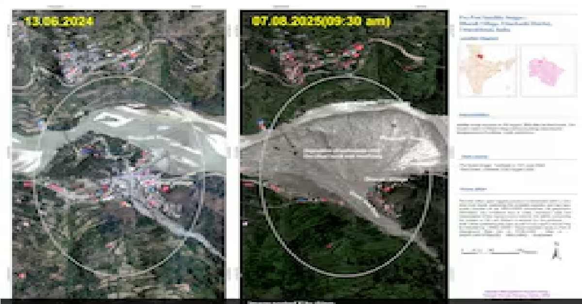
Two days after the floods, ISRO's Cartosat-2S satellite captured high-resolution images of the affected zone.
New Delhi 08 August 2025
As per news report of NDTV,Satellite images, extracted by the Indian Space Research Organisation (ISRO), have revealed the scale of destruction caused by the deadly flash floods in Uttarakhand's Uttarkashi earlier this week. The disaster, on August 5, killed five people and left over 50 people missing. Experts suspect the burst of a glacial pond triggered the deluge.
Source - NDTV
If you like the story and if you wish more such stories, support our effort Make a donation.
Trending News
Are Stock Markets Shut For Ram Navami Today? Check NSE, BSE Holid...
3/26/2026
Thu Mar 26 2026 | By Newsdesk

India Raises Climate Ambition: 47% Emissions Cut, 60% Clean Energ...
3/26/2026
Thu Mar 26 2026 | By Newsdesk

If Superstitions Worked, Terrorists Could Be Killed With Needle: ...
3/26/2026
Thu Mar 26 2026 | By Newsdesk
Poll Body Transfers Bengal Official Over Complaints Of Irregulari...
3/26/2026
Thu Mar 26 2026 | By Newsdesk

Parvesh Verma Compares Arvind Kejriwal To 'Rehman Dakait', AAP Hi...
3/26/2026
Thu Mar 26 2026 | By Newsdesk